Accommodations Nova Scotia
Your Guide To Accommodations In Nova Scotia
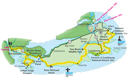
Marconi Trail, Nova Scotia
Step through a doorway in time into a magnificent French
town whose streets are a bustle of 18th-century activity.
This is Fortress Louisbourg, the largest historic
reconstruction in North America. Inside the massive stone
gates, the year is 1744. Come stroll the lively streets
where costumed washerwomen, bread sellers, soldiers,
noblemen and musicians are going about their daily business.
Explore historic period gardens, watch musket and cannon
drills, roam through the king's storehouses, and visit the
homes of commoners, merchants, and wealthy residents.
Meticulously rebuilt on the foundations of the original
Fortress, this is the site from which the French controlled
their trade with the new world in the 1700s.
Fortress Louisbourg highlights the French heritage of the
Fleur-de-lis and Marconi trails. Picturesque fishing
villages with a distinctly Acadian flavour lie along the
rugged sea coast. This is also Canada's richest coal
country, and the history of the region's coal mining is
captured at Glace Bay's Miners Museum where visitors can
tour a historic miners village and enter a real coal mine,
the Ocean Deeps Colliery.
The communities that owe their existence to the coal-mining
industry form the foundation of the Colliery Route, which
follows the coastline from Glace Bay Harbour to Sydney
Harbour; brochures are available at information centres and
at the various sites along the route.
The Marconi National Historic Site marks the location of the
first west-to-east transatlantic radio transmission in 1902,
and the Sydney and Louisburg Railway Museum pays tribute to
the region's rich railway history.
Florence is a former mining community.
Route 305 ends at Little Bras d'Or at Exit 18.
Highway 105 to the left leads back to North Sydney and
Sydney. Right on Highway 105 leads to Baddeck and
the Cabot
Trail.
The Fleur-de-lis Trail continues its inland course to arrive
at Gabarus Lake. A dirt road to the left goes to Victoria
Bridge on the Mira River.
Near Gabarus, a small fishing village, the
Fleur-de-lis Trail joins Route 327. Straight ahead is the
village of Gabarus, while a left turn on the Trail leads to
Marion Bridge.
At Marion Bridge, right, the Fleur-de-lis Trail follows the south side of
the Mira River, one of Nova Scotia's largest rivers, through
Trout Brook to Albert Bridge. Straight ahead at Marion
Bridge, Route 327 leads to Sydney, 15 km away. A left turn on the
north side of the Mira River towards Huntington, Salmon
River Road and Victoria Bridge
leads to Two Rivers Provincial Wildlife Park.
The Fleur-de-lis Trail continues at Albert Bridge, where the beautiful Mira River offers swimming,
boating and canoeing. Many summer cottages are situated
along this river and at Catalone. Turn right on
Route 22. A left turn on Route 22 leads back to Sydney. Near
Albert Bridge, off Route 22, right, is Mira River Provincial Campground Park
. Route 22, the Fleur-de-lis Trail, leads south to
Louisbourg and the Marconi Trail.
The Marconi Trail and
the Fleur-de-lis Trail, Route 22, join
on the outskirts of Louisbourg. Both trails proceed into the
town of Louisbourg.
Louisbourg, located on the shores of a
naturally ice-free harbour, has welcomed travellers for some
250 years. The community is still an important port for the
landing of lobster, crab, shrimp, and other species, and in
August, Louisbourg Crabfest celebrates the bounty of the
sea.
Visitors will enjoy strolling along the harbour front
boardwalk, with its interpretive signage, and the pier.
Within walking distance of the docks are Louisbourg Market
Square, shops, museums, ship chandlery,
accommodations, post
office and other services. The Louisbourg Playhouse offers
live theatre and concerts nightly during the summer and
fall. At the harbour entrance, the Louisbourg Lighthouse
stands adjacent to the ruins of Canada's first lighthouse,
which dates back to 1734. The visitor information centre is
located in the S&L Railway Museum, which recalls the
importance and romance of the railway era.
Fortress of Louisbourg, covering some 6,700 ha, is the largest national historic site in Canada, and
includes one of the three largest restorations in the world.
Parks Canada has restored one-quarter of the 18th-century
town, including many of its buildings and much of its
masonry and earth-packed fortifications.
Once you leave the fortress, drive to other areas in the
park that are noted for their scenic beauty and historic
significance, such as Lighthouse Point, Careening Point,
Royal Battery and Kennington Cove. More information on these
locations can be obtained from the guides at the site's
Visitor Reception Centre.
The road leading past the entrance to the Fortress of
Louisbourg National Historic Site continues to Kennington
Cove, 7 km away, where there is a beach park with
picnic facilities.
The Marconi Trail is named for Italian inventor Guglielmo
Marconi, who spent several years in Cape Breton establishing
three transatlantic wireless stations. The first was built
at Table Head, Glace Bay, where on December 15, 1902, the
first transatlantic wireless message was sent to England. A
second wireless station was built on Marconi Towers (on Sand
Lake Road) in 1907 and became the main transmitting station.
A third station built in Louisbourg in 1913 was a
transatlantic receiving station. Today all that remains of
the wireless stations are concrete blocks on which stood the
giant wooden towers that housed the copper wire transmitters
and receivers.
The Marconi Trail is a 60-km paved road from
Louisbourg to Glace Bay, skirting portions of the rugged
coastline and approximately linking the three historic
Marconi transatlantic wireless station sites.
The Marconi Trail begins in Louisbourg. Just north of town,
the Marconi Trail leaves the Fleur-de-lis Trail, veering
right through forests of stunted spruce.
Little Lorraine is a small fishing port located
at the end of a narrow ocean inlet. Beyond Little Lorraine,
a dirt road on the left leads to Baleine. It was here that
Sir James Stewart, Lord Ochiltree, attempted a settlement in
July 1629. The land grants were made eight years earlier by
King James I of Scotland to the Baronets of New Scotland.
The Baleine encampment, known as the Barony of New Galloway,
was captured and burned by Captain Charles Daniel Dieppe,
who gave it the name Port aux Baleines, "Whale Harbour." In
1936, British aviatrix Beryl Markham crash-landed her plane
at Baleine during her solo flight across the Atlantic. A
14-km hiking trail along the coastline starts at the
beach at Baleine.
Main-a-Dieu is the largest fishing village on
this coast. Main-à-Dieu has a large wharf and fishing fleet
with many boats engaged in the lobster fishery in spring and
summer. There is a scenic ocean side boardwalk that goes
around a sandy beach and takes about 15 minutes to complete.
Turn left leaving Main-à-Dieu; the Marconi Trail travels
around the shores of Mira Bay.
Keep left for Catalone Gut, where a sandbar
separates Mira Bay from Catalone Lake. The lake is popular
with canoeists, and the ocean side of the bar offers a sand
beach.
At Mira, the Mira River, one of Nova Scotia's longest,
empties into Mira Bay. A campground with go-carts and a
water slide is located upriver on the Hills Road, Route 255
to the left.
The Marconi Trail continues on Route 255 straight ahead, to
Round Island, where there are numerous summer cottages on
Mira Bay.
At Homeville, a right turn leads over the False
Bay Lake bridge to South Port Morien. The shallow water near
the bridge is a good place for bird watching and clam
digging. The gravel road leads to Wadden's Cove, where there
is a small beach. Hikers may follow portions of the coast to
the tip of the Cape Morien peninsula.
Port Morien has an active fishing fleet and a
breakwater. There are some stores and visitor services in
the village. The first coal-mining operation in North
America took place along the cliffs at Port Morien in the
1720s, when French troops from the nearby Fortress of
Louisbourg dug into the exposed seams.
Straight ahead, Route 255 leads to Birch Grove and Marconi
towers, then to Glace Bay.
From Port Morien, the Marconi Trail bears right to Donkin
along the coast. Donkin is a former coal-mining
centre and has a variety of visitor services. Some of the
ocean cliffs along the Marconi Trail contain outcroppings of
coal, and the dark seams can be seen easily from the
highway.

